This site is an effort by county, state, tribal, and federal agencies to coordinate and aggregate information for Idaho communities affected by wildfire smoke. The information is posted here by the agencies themselves.
Idaho Smoke Map
Idaho Smoke Map Legend
**(Preliminary Data Warning: Data found on the map shown below is preliminary and is subject to change. Data is in local standard time format - no adjustment for daylight savings time.)
Pages
We Want to Hear From You!
We encourage posting of your comments and concerns on this blog so we can better serve you. Please click the link that may say "no comment" at the bottom of each blog post. That will take you to a comment box where you can let us know what you think. We will make every effort to respond to your comments within 24 hours. We appreciate your patience as we find the most knowledgeable person to answer your question.
Thursday, July 2, 2020
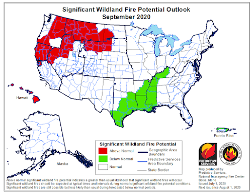
Updated Wildfire Outlooks
Well, it looks like all the rain in June might hold off an "above normal" season for a lot of you for a little longer. July is now looking "normal" for most of the state (notably the northern portion of the state changed from "above normal" to "normal"). By August, however, we'll move into period where the entire state of Idaho has "above normal" significant wildfire potential and this will continue into September for most of the state. If you haven't already, skim through the posts in June to learn about how to protect yourself from wildfire smoke. Stay safe and have a good holiday weekend!
Subscribe to:
Post Comments (Atom)


No comments:
Post a Comment